


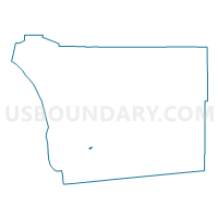
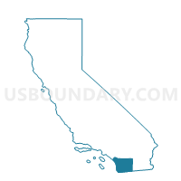
Voting District 20808, San Diego County, California
About
Outline

Summary
| Unique Area Identifier | 542001 |
| Name | Voting District 20808 |
| County | San Diego County |
| State | California |
| Area (square miles) | 0.31 |
| Land Area (square miles) | 0.30 |
| Water Area (square miles) | 0.01 |
| % of Land Area | 96.49 |
| % of Water Area | 3.51 |
| Latitude of the Internal Point | 32.76721930 |
| Longtitude of the Internal Point | -116.99492200 |
Maps

Graphs
Select a template below for downloading or customizing gragh for Voting District 20808, San Diego County, California


Neighbors
Neighoring Voting District (by Name) Neighboring Voting District on the Map
- Voting District 20790, San Diego County, CA
- Voting District 20811, San Diego County, CA
- Voting District 20817, San Diego County, CA
- Voting District 20904, San Diego County, CA
- Voting District 21306, San Diego County, CA
Top 10 Neighboring County Subdivision (by Population) Neighboring County Subdivision on the Map
Top 10 Neighboring Place (by Population) Neighboring Place on the Map
Top 10 Neighboring Elementary School District (by Population) Neighboring Elementary School District on the Map
Top 10 Neighboring Secondary School District (by Population) Neighboring Secondary School District on the Map
Top 10 Neighboring State Legislative District Lower Chamber (by Population) Neighboring State Legislative District Lower Chamber on the Map
Top 10 Neighboring State Legislative District Upper Chamber (by Population) Neighboring State Legislative District Upper Chamber on the Map
Top 10 Neighboring 111th Congressional District (by Population) Neighboring 111th Congressional District on the Map
Top 10 Neighboring Census Tract (by Population) Neighboring Census Tract on the Map
- Census Tract 138.01, San Diego County, CA (4,771)
- Census Tract 149.01, San Diego County, CA (4,243)
- Census Tract 152, San Diego County, CA (3,879)
- Census Tract 149.02, San Diego County, CA (3,186)
- Census Tract 137.01, San Diego County, CA (2,352)